Article

Exploring Options for Flood Risk Management with Special Focus on Retention Reservoirs

1
Faculty of Civil and Geodetic Engineering, University of Ljubljana, 1000 Ljubljana, Slovenia
2
Faculty of Civil Engineering, University of Zagreb, 10000 Zagreb, Croatia
3
Faculty of Civil Engineering, University of Duisburg-Essen, 45141 Essen, Germany
4
Biotechnical Faculty, University of Ljubljana, 1000 Ljubljana, Slovenia
*
Author to whom correspondence should be addressed.
Sustainability 2021, 13(18), 10099; https://doi.org/10.3390/su131810099
Submission received: 13 August 2021 / Revised: 6 September 2021 / Accepted: 7 September 2021 / Published: 9 September 2021

Abstract

:
Floods are among the most frequent and deadliest natural disasters, and the magnitude and frequency of floods is expected to increase. Therefore, the effects of different flood risk management options need to be evaluated. In this study, afforestation, permeable concrete implementation, and the use of dry and wet retention reservoirs were tested as possible options for urban flood risk reduction in a case study involving the Glinščica river catchment (Slovenia). Additionally, the effect of dry and wet reservoirs was investigated at a larger (catchment) scale. Results showed that in the case of afforestation and permeable concrete, large areas are required to achieve notable peak discharge reduction (from a catchment scale point of view). The costs related to the implementation of such measures could be relatively high, and may become even higher than the potential benefits related to the multifunctionality and multi-purpose opportunities of such measures. On the other hand, dry and wet retention reservoirs could provide more significant peak discharge reductions; if appropriate locations are available, such reservoirs could be implemented at acceptable costs for decision makers. However, the results of this study show that reservoir effects quickly reduce with scale. This means that while these measures can have significant local effects, they may have only a minor impact at larger scales. We found that this was also the case for the afforestation and permeable concrete.

1. Introduction

Floods are natural disasters that can cause large economic damage and endanger human lives [1,2,3,4]. Moreover, the magnitude and frequency of floods are expected to increase in many parts of world in future decades due to climate change [5,6,7,8]. Additionally, the seasonality of floods is changing throughout the globe [9]. Therefore, different structural and non-structural measures will inevitably need to be implemented to cope with the increasing flood risk [10,11,12]. Flood forecasting can be one of the solutions to warn people living in flood hazard areas [13,14,15] in the case that prevention measures are not sufficient or cannot be implemented. Efficient flood forecasting requires good input data for model set-up and conducting forecasts. Additionally, meteorological forecasting of suitable quality and lead-time should be used for the prediction of the hydrological conditions.
More specifically, green, blue, gray, and hybrid measures can be used to lower flood risks [10,16,17,18,19]. However, it is not always clear if a specific green or blue measure is able to provide sufficient flood risk reduction given the variety of hydrological conditions [20]. Therefore, additional research, directed into site specific conditions, is needed in order to better evaluate the impact of different measures on the hydrological conditions within the catchment and consequently on flood risks [17,21]. A second need stems from the fact that limited social acceptance of purely green measures often encounter resistance in planning departments due to institutional path dependency related to the history of utilizing grey measures. Therefore, their implementation is often limited. This is often the case in the Central-Eastern European countries [17,22] such as Slovenia. Moreover, these countries also use so called ad-hoc instruments that are implemented directly after catastrophic flood events [23] and generally invest less funds into water-related infrastructure compared to other western countries [24]. Modelling approaches and case studies investigations can help in creating a scientific basis to support implementation of specific flood risk measure and speed up implementation procedure by environmental engineers and spatial planners. Most of the studies that have been conducted so far took into consideration one specific flood risk management option and a comparison of different measures is not carried out [21,25,26,27,28]. Only limited number of studies took into consideration multiple flood risk reduction measures [29]. Additionally, some studies have shown that, in view of the impact of afforestation on the rainfall-runoff formation, only specific forest types have a flood mitigation effect while coniferous trees do not [30]. Therefore, additional research is needed to better evaluate the usefulness and impact of different measures at various spatial scales.
The main aim of this study was to evaluate the effect of different flood risk management measures that can be used to cope with increasing flood risk from the perspective of peak discharge, potential damage, and benefits of the measures. More specifically, afforestation, permeable concrete implementation, and dry and wet retention reservoirs were taken into consideration. Moreover, a comparison among these measures was carried out. Additionally, evaluation of the hydrological effect of dry and wet retention reservoirs on the flood risk was performed where special focus was given to the scaling effect of these objects. To sum up, the main motivation behind this study was to enhance the scientific basis related to flood risk management by exploring the effect of different measures on the hydrograph formation and related flood damage.

2. Materials and Methods

2.1. Glinščica River Catchment and Models Used

The partially urbanized Glinščica river catchment was selected as a case study to evaluate the effect of afforestation, permeable concrete implementation, and dry and wet retention reservoirs on the flood risk. The catchment area before the confluence with the larger Gradaščica river is 16.9 km2 (Figure 1). This case study is one of the experimental catchments in Slovenia [21,31,32,33] and was selected since it was already used in previous applications and since it is a hydrological, a hydraulic and a flood damage model for this catchment are already set-up, calibrated, and evaluated using the data obtained at the scope of the measurements within the experimental catchments. The eastern and western parts of the catchment are hillier and mainly forested while central and southern parts are flatter and more intensively urbanized (Figure 1). The elevation ranges from about 210 to about 590 m.a.s.l., the mean annual precipitation is around 1400 mm, and the catchment time of concentration is around 6 h [31]. Forest covers around 50% of the area while agricultural and urbanized areas both cover around 20% of the catchment [31]. According to the Soil Conservation Service (SCS) methodology, the soil characteristics can be classified into C and D types with generally low infiltration rates [31]. A detailed description of the catchment can be found in previous studies [21,31,32].
Similarly as Johnen et al. [21] this study used the hydrological HEC-HMS, the hydraulic model HEC-RAS, and the flood damage KRPAN model. The HEC-HMS model is one of the most frequently used rainfall-runoff models that includes simulation of the most relevant hydrological processes [34]. A variety of traditional hydrological methods is included in the software that can also be used for the continuous rainfall-runoff or event-based simulations [34]. In the scope of this study, the rainfall losses were calculated using the SCS Curve Number (CN) method [32,34] where the CN parameter was estimated based on the land-use map and the SCS soil type map [21]. The transformation of the effective rainfall to runoff was done using the synthetic unit hydrograph method where again the SCS method was used and the lag time parameter was calculated using the catchment characteristics [21]. There are other options available such as user defined unit hydrograph curves that were used in some other previous studies and yield a bit smaller peak discharge values [32,35]. For the sensitivity analysis conducted in the scope of the Section 2.5 also the Clark unit hydrograph method was tested [34]. Similarly as Johnen et al. [21] the simulations in this study were also conducted for the 2, 10, and 25-years return periods. The design rainfall event was determined using the intensity-duration-frequency (IDF) curves and Huff curves as described by Bezak et al. [31]. Gauged data from the nearby Ljubljana-Bežigrad station was used [31]. The results (i.e., hydrographs) of the hydrological simulations using the HEC-HMS model were used as upper boundary condition to the hydraulic HEC-RAS model [31].
The HEC-RAS model, among others, allows performing one and two dimensional steady and unsteady flow simulations for a variety of natural or constructed river sections [36]. The lower section of the Glinščica river catchment was also modelled with the HEC-RAS software (Figure 2) where a combination of one and two dimensional unsteady flow simulations was used as described by Bezak et al. [31]. A detailed description of the methodology used is provided by Bezak et al. [31]. The results of the HEC-RAS simulations, floodplain water depths and flood extent were used as input to the flood damage KRPAN model.
The flood damage KRPAN model was developed specifically for the entire area of Slovenia taking into consideration all the relevant input data [21,37]. The model uses different flood depth-damage equations, census and market values data for each sector such as cultural heritage, economic activities and environment in order to derive the expected damage based on the floodplain water depth and extent [37]. The input to the model is polygon of the flood extent with the information about the water depth as polygon attribute and the output is the expected damage for different sectors [21,37]. The model was already used in previous applications [21] with a similar type of model also developed for Croatia [38].

2.2. Afforestation

Afforestation is one of the nature-based solutions that can be used for peak flow reduction and this measure can provide multiple eco-system benefits and services as well [21]. The initial study where different flood risk management options were evaluated for the Glinščica river catchment was conducted by Johnen et al. [21] who evaluated the effect of afforestation on the flood risk within this study area. Due to the consistency with the description of the others steps done in the scope of this study (Section 2.3, Section 2.4 and Section 2.5) this paragraph will briefly summarize the main methodological steps done by Johnen et al. [21] as well as the main results they obtained [21]. The cost-benefit analysis (CBA) was also conducted in order to evaluate the effect of afforestation on the flood risk for the 2, 10, and 25-years return periods [21]. Multiple potential ecosystem services of the potentially afforested areas were taken into consideration such as biodiversity, carbon capture, recreational value, and water quality. Three different scenarios of land-use modification in different parts of the catchment were taken into consideration within the study conducted by Johnen et al. [21]. It should be noted that various scenarios are potentially feasible but the selected three scenarios also include the situation with maximum and minimum possible effect of afforestation. The same combination of the three models as described in Section 2.1 was used to evaluate the effect of afforestation [21]. A description of the main results is summarized in Section 3.1 of this study.

2.3. Permeable Concrete

A second hypothetical option that was taken into consideration for flood risk management in case of the Glinščica river catchment is permeable concrete implementation. Permeable concrete is known to provide a cost-effective solution to the problem of localized urban flooding due to its ability of reducing storm-water runoff [39,40,41,42]. Moreover, permeable concrete (or pavement) also has multiple cold-weather benefits such as less road salt needs to be applied in winter with air stored in the material, which can have a positive effect on melting the snow or ice cover [43,44]. The costs of the permeable concrete can be calculated by addressing the construction and maintenance costs of implementing permeable concrete on built and similar areas of the Glinščica river catchment. However, the benefits are mainly ecological, such as mitigation of “first flush” pollution, reduction of surface temperature and heat island effects, protection of streams, watersheds, and ecosystems, which can often be hard to express in economic value [42]. The idea behind applying the permeable concrete to the Glinščica river catchment was replacing existing built-up areas in the catchment with permeable concrete. It should be noted that this should be regarded as a hypothetical example since such solution is practically impossible to implement at such large scale. As noted, permeable concrete solutions are mainly implemented at much smaller scales as parking lots or parts of streets. Additionally, the implementation of permeable concrete also requires soils with good infiltration rates. To evaluate the proposed approach, the combination of three models as described in Section 2.1 was used. Similarly as in the case of Johnen et al. [21] three scenarios and initial land-use (additional baseline scenario) were used. Firstly, the input to the models was the present (i.e., initial) situation at the Glinščica river catchment with current land use parameters (methodology described in Section 2.1). Secondly, the hypothetical scenarios of permeable concrete cover were considered as follows:
  • Scenario 1: all built and similar areas (subbasins 1, 2 and 3) in the Glinščica river catchment were replaced with permeable concrete.
  • Scenario 2: all built and similar areas of subbasin 1 and subbasin 2 were replaced with permeable concrete.
  • Scenario 3: all built and similar areas of subbasin 1 were replaced with permeable concrete.
The three subbasins together with the initial (i.e., present) CN values are shown in Figure 2. There are more possible scenarios that could be investigated. However, the selected three scenarios should reveal the maximum (Scenario 1) and minimum (Scenario 3) impact of the selected measure.
To address the application of permeable concrete in the hydrological model HEC-HMS, values of SCS CN parameter were adjusted according to the literature review [45]. More specifically, the values of CN 50 and CN 74 [45] were chosen in comparison with the current situation CN 91 for built and similar areas of the Glinščica river catchment. This means that for the land-use type built and similar areas the CN was changed from 91 to 50 and 74. Thus, for all three scenarios mentioned above new total CN values (for each subbasin) were calculated using both CN values, 50 and 74.
The HEC-HMS modelling results (i.e., hydrographs) for the 2, 10, and 25-years return periods were used as input for the hydraulic model HEC-RAS (Section 2.1). Similarly as in the study of Johnen et al. [21], changes were also made within the hydraulic model by modifying the Manning values for the built and similar areas regarding different scenarios and compared with the situation of current Manning value parameter [36]. The value of 0.03 [28] was used as the Manning roughness coefficient (n) for built and similar areas for the application of permeable concrete while in case of baseline scenario a value of 0.045 was used [21]. As described in Section 2.1, results of the HEC-RAS model were used as input to the KRPAN model in order to estimate the expected damage.

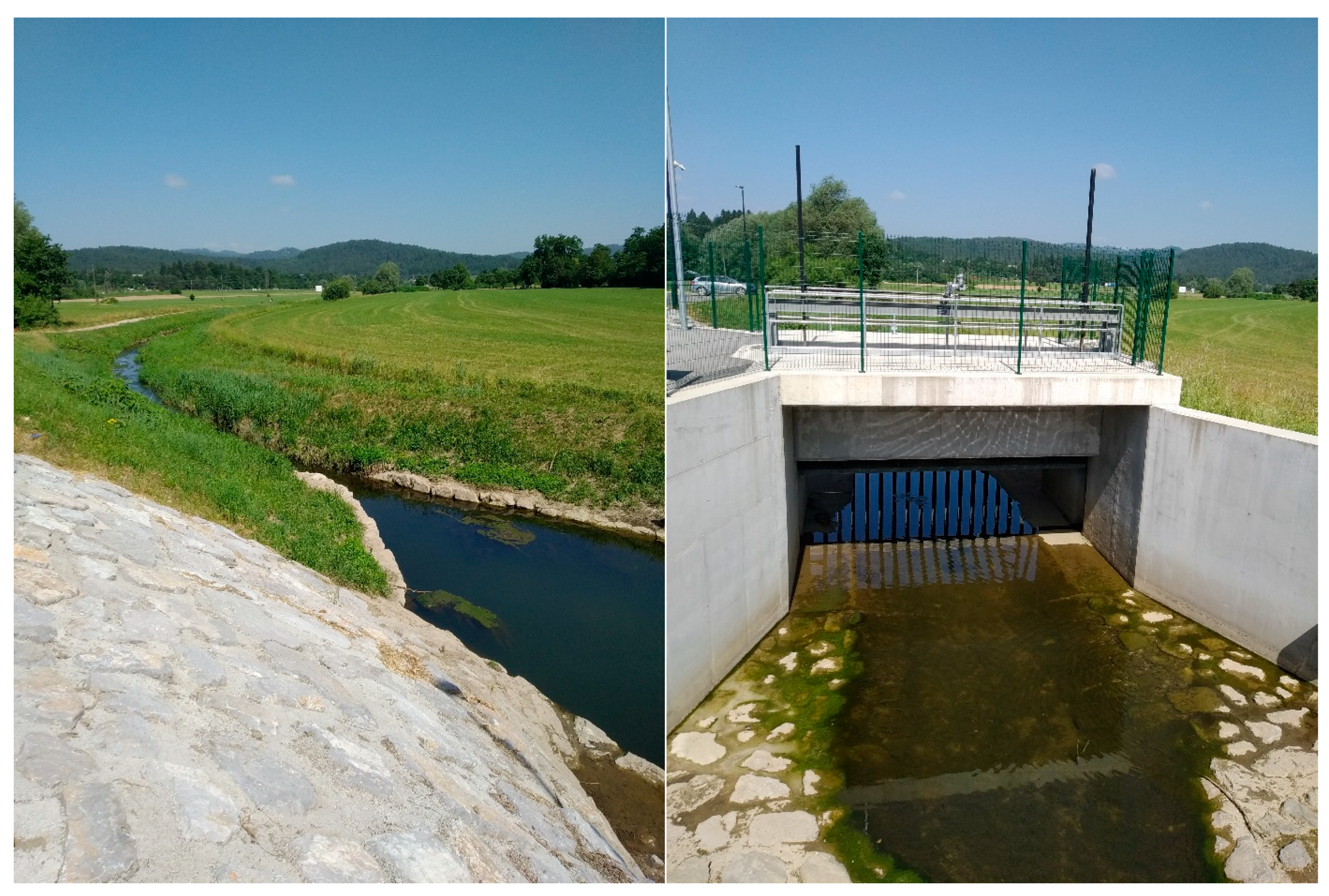
2.4. Retention Reservoirs

There are two retention reservoirs located in the Glinščica river catchment (Figure 1). The upstream one is the wet retention reservoir named Podutik that was constructed more than 30 years ago [46]. After the construction, the area was not regularly maintained, which led to increased presence of vegetation in the reservoir (Figure 3). Therefore, in the year 2019, the vegetation in reservoir was removed and large maintenance and reconstruction was carried out with aim to re-establish the flood safety of the downstream areas by increasing flood retention volume (Figure 3) [47,48]. The total cost of the re-construction was around 500,000 EUR [47]. In this wet reservoir the water level is retained using simple outlet and spillway without any additional hydro-technical equipment [48]. Figure 3 also shows some main characteristics of the Podutik reservoir and arrangement of the outlet section from the retention reservoir. This reservoir was also used as one of the case studies to create multifunctional blue-green infrastructure [49].
The downstream reservoir Brdnikova was constructed around 50 years ago and was subsequently improved (i.e., much large volume) and modified in 2019. The total costs of the project, which included raising the road levee, construction of outlet control section with gate, and reconstruction of road bridges were around 7,600,000 EUR The costs directly related to the construction of the reservoir were around 2,400,000 EUR [50]. The area upstream of the outlet control section equipped with automatically regulated hydro-mechanical gate is flooded only during flood events (Figure 4). This kind of structures are relatively frequently used in Slovenia to deal with flood risk [51]. The maximum retention volume after the reconstruction is estimated at 450,000 m3 (flooded area in this case is around 42 ha) [52]. Land use in this reservoir is extensive agriculture (predominantly meadows).
It should be noted that simulations done in the scope of Section 2.2 and Section 2.3 did not consider the effect of both reservoirs within the hydrological model HEC-HMS. The main idea was therefore to evaluate the effect of the individual measure on the flood risk (peak discharge reduction and flood damage using KRPAN model). Thirdly, as an option for the flood risk management in the Glinščica river catchment, both reservoirs were implemented in the HEC-HMS hydrological model using the reservoir tool [34]. To account for the volume of the reservoir, the elevation-storage method was used where the volume of the potentially flooded area was determined based on the lidar data (i.e., 1 m grid cell). The elevation-storage function was later validated using the information about the area of the Podutik reservoir that is always flooded (i.e., around 5500 m2) [48] and based on the field survey (i.e., estimated water depth). A similar validation was conducted for the Brdnikova reservoir using the data from the project documentation [52]. Similarly, other details needed to correctly model both reservoirs using the HEC-HMS model were obtained using lidar data, field surveys or project documentation (e.g., initial conditions, main tailwater, stage) (Table 1). The outflow from the Podutik reservoir was modelled as combination of box culvert outlet and high-discharges spillway (Table 1). Moreover, outflow from the Brdnikova reservoir was modelled using box culvert outlet opening [34] (Table 1). Since the HEC-HMS model does not include any option to operate gates within an outlet during the simulation, the gates were modelled using a fixed stage (i.e., fixed rise of the culvert outlet) in case of the Brdnikova reservoir. The characteristics (e.g., dimensions, entrance and exit coefficients, outlet elevation, Manning’s n) of these structures were determined using a combination of field survey, lidar data and documentation guidelines [34] (Table 1).
The methodology described in Section 2.1 was also used in case of the dry and wet reservoirs where a comparison of peak discharge values and KRPAN results was made for the simulations with and without the reservoirs.

2.5. Sensitivity Analysis Using Retention Reservoirs

Since some studies have shown that the effect of small retention reservoirs can be relatively small at larger scales [25], the idea was to evaluate how does the effect of the Podutik and Brdnikova reservoirs changes with scale. Therefore, a hydrological model of the Glinščica river catchment was complemented with the adjacent Gradaščica river catchment and larger Ljubljanica river catchment (Figure 5). This means that Gradaščica river catchment (158 km2) up to the confluence with the Glinščica river was added to the model as a separate catchment using the subbasin creation tool in the HEC-HMS [34]. A Similar procedure was applied for the Ljubljanica river catchment (1585 km2) up to the confluence with the Gradaščica and Glinščica rivers. The SCS and Clark methods were used as transformation methods (i.e., effective rainfall to runoff) in case of the Gradaščica and Ljubljanica rivers, respectively. Since the Ljubljanica river catchment has significant karst characteristics [53,54], the Clark method was selected since this method also uses storage coefficient [34]. Since the Ljubljanica river catchment up to the Moste gauging station (i.e., located few kilometers downstream of the confluence of the three rivers) was investigated in previous studies [54,55,56] the prepared daily discharge as well as areal precipitation data from these studies were used. Thus, SCS and Clark parameters for the Gradaščica and Ljubljanica catchments were calibrated using areal precipitation (details about stations used and methodology applied are provided by Sezen et al. [55]) and daily discharge data measured at the Moste gauging station.
Using the calibrated model, the effect of the Podutik and Brdnikova reservoirs at larger scales was evaluated. Moreover, a sensitivity investigation was performed to see how the volume of retention reservoirs effects hydrological conditions during actual rainfall events (i.e., rainfall events that occurred in September 2007 and 2010). This means that actual rainfall events were investigated instead of the synthetic design rainfall events that were used in the scope of Section 2.2, Section 2.3 and Section 2.4. Different cases were investigated and are shown in Table 2. It should be noted that changes in the volume of reservoirs can be regarded equally similar to the potential changes in the number of reservoirs. For example, 10-times larger volume can be regarded as 10 individual reservoirs, which would be positioned within the catchment. It should be noted that Razori and Brezje reservoirs are planned to be constructed at the Gradaščica river catchment with total effective volume of both reservoirs approximately equal to the 10 times the volume of the Brdnikova reservoir.

3. Results and Discussion

3.1. Afforestation

Table 3 shows main results that were obtained in a study conducted by Johnen et al. [21]. It can be seen that peak discharge reductions through afforesting floodplains as a flood risk management option were relatively small (i.e., less than 15%) for all three tested return periods. Larger differences were obtained for the flood damage for the subbasin 3 (Figure 2 and Table 3). Since there are relatively a lot of information available about the positive ecosystem services of trees, Johnen et al. [21] were also able to conduct a detailed CBA. The calculated net present values were only positive for one of the three scenarios (i.e., afforestation downstream) where the main reason for such results was the modification of the floodplain roughness within the hydraulic model, which had bigger effect on the flood damage [21]. In the other scenarios the CBA indicated that costs were higher than the benefits of the hypothetical measures [21]. Therefore, afforestation as a sole flood protection measure is unlikely to cause enough peak flow reduction in order to ensure the flood safety, especially at larger scales, but can be used as a supplementary measure especially due to the multiple ecosystem services that trees can provide [21]. It should be noted that for the two-years return period the extent of the flooded area and consequently the flood damage is relatively minor (Table 3).

3.2. Permeable Concrete

Table 4 shows main results obtained for the case study where an implementation of permeable concrete was investigated. The analysis was conducted considering three different scenarios with varying CN values for permeable concrete and different return periods (Section 2.3). All scenarios were analyzed for the CN 50 (a) and CN 74 (b) for the built areas in which concrete was virtually replaced with permeable concrete (Section 2.3). The results showed that reduction of the flood hydrograph peak and flood damage were lowest for scenario 1 and highest for scenario 3. In addition, CN 50 of the observed built areas lowered the peak even further and reduced the flood damage compared to the baseline situation (Table 4). The difference between the highest and lowest flood peak regarding analyzed scenarios depended on the return period of the observed flood hydrographs and the chosen CN (Table 4). Economic damages simulated using the KRPAN flood damage model showed that higher return periods (25 years) combined with no application of permeable concrete (i.e., baseline scenario) resulted in the highest flood damages. However, the lowest flood damage of all analyzed scenarios was associated with scenario 1 (i.e., all built and similar areas replaced with permeable concrete; CN 50) and two-year return period where flood damage was minor (Table 4). Peak discharge and economic damage decreases are generally larger compared to the afforestation case study (Table 3). The main reason is since the agricultural areas that were hypothetically changed to forest in case of study conducted by Johnen et al. [21] cover around 3.6 km2 while the built areas that were modified in this study cover around 6 km2. Furthermore, a lower CN value that was used (i.e., 50) is substantially smaller compared to the initial CN value for built and similar areas, which was set to 91.
This study investigated a hypothetical example and hence all areas that are classified as built and similar areas (Figure 2) cannot be changed to permeable concrete since this land-use category includes also buildings and similar objects. Furthermore, huge costs would be related to such construction even in hypothetical case where built areas would only be composed from roads, parking lots, etc. According to the CNT Green values stormwater management calculator [52], the construction costs for permeable parking, streets, etc. are around 8.7 dollars per ft2, which is equal to around 80 EUR per m2. Even if this number is slightly reduced and adopted for Slovenian conditions (e.g., price per m2 of asphalt is around 40–50 EUR) and 50 EUR per m2 is used, still a huge number is obtained that exceeds 200 million EUR. Additionally, maintenance costs are annually estimated to be around 0.02 dollars per ft2 [57], which is equal to around 0.2 EUR per m2 per year. Thus, this yields approximately 1 million EUR of maintenance costs per year in case that entire built and similar areas would be changed to permeable concrete (i.e., around 6 km2).
The largest economic damage decrease calculated using the combination of models as described in Section 2.1 was around 500,000 EUR (Table 4) and was obtained for the 25-years return period and using scenario 1 and a CN value of 50. In all other cases, the estimated economic damage decrease (i.e., compared to baseline) was smaller. It should be noted that these numbers correspond to the one specific flood event. If multiple flood events occur, these damage decrease should be multiplied with the number of events. However, permeable concrete is beneficial (besides flood protection due to smaller runoff) in terms of health benefits (e.g., improved indoor environment quality), economic benefits (e.g., improved workforce development), climate adaptation (e.g., reduced urban heat islands), transportation benefits (e.g., reduced on-street flooding) [42]. Furthermore, improved infiltration that is characteristic of permeable concrete also has a positive effect on the groundwater recharge rate. Moreover, as already mentioned, there are also several benefits related to winter periods such as less road salt needed in winter and air stored in the material can have a positive effect on snow melting [43,44]. Therefore, a detailed CBA would need to be conducted to more comprehensively evaluate all the positive effects of permeable concrete in relation to the high construction and maintenance costs. However, it seems that high construction costs (e.g., compared to afforestation) indicate that such measures are more likely to be implemented at smaller scales in case of maintenance of existing urban areas (i.e., streets, parking lots). However, such option could be a good alternative for newly constructed areas where permeable concrete (or asphalt) can be selected as a valuable decentralized flood risk management alternative to classical measures or as a supplementary measure.

3.3. Dry and Wet Retention Reservoirs

Inflow and outflow hydrographs for the Podutik and Brdnikova reservoirs for the 2- and 25-years return period are shown in Figure 6. It can be seen that the Brdnikova reservoir can lower the peak discharge in case of the 25-years return period event for about 45% while this decrease is bit smaller in case of 2-years return period event (i.e., 32%). Moreover, there is a clear effect on the timing of the peak discharge that is shifted for about 2 h and 1 h in case of the 25-years and 2-years events, respectively (Figure 6). On the other hand, the effect of the Podutik is smaller, the peak discharge reduction is around 30% and 5% for the 2- and 25-years return period, respectively (Figure 6). This can of course be attributed to the smaller retention volume of this reservoir that is already full to some extent before the occurrence of a flood event (Figure 3). Moreover, also the Podutik reservoir leads to a bit lagged occurrence of the peak discharge (i.e., up to 1 h). However, even such small lag-time might be important in view of mitigating the impact of urban drainage system on the discharge conditions in small streams draining urban areas, such as Glinščica stream. As already noted, the flooded area in case of the 2-years event is almost negligible and such retention reservoirs are able to almost completely reduce the flood damage in case of floods with moderate return periods.
Next, the peak discharge reduction at the outflow of the hydraulic model and the economic damage reduction were evaluated. Results of this analysis are shown in Table 5. It can be seen that the application of one wet and one dry reservoir (i.e., Podutik and Brdnikova) significantly reduced the peak discharge and consequently the calculated economic damage caused by the flood (Table 5). Moreover, the estimated decrease is larger compared to the estimated decrease using other measures as afforestation or the application of permeable concrete. Moreover, the construction costs of such retention reservoirs seem to be much lower compared to the costs related to the implementation of the permeable concrete at large areas (Section 2.3). Of course, implantation of such reservoirs requires sufficient available space and suitable position to be implemented. Thus, it is not always possible to implement such objects that are in most cases positioned on generally flat areas where the flow velocities are smaller compared to hilly areas that have torrential characteristics [58,59].
Dry reservoirs also have an effect on agricultural production, since in most cases the land used to construct the retention volume is used for agricultural purposes [51,52]. More specifically, reservoirs tend to decrease the productive capacity of landscape while having negative effect on soil properties [51]. Additionally, a negative impact on the crop quality and quantity as well as infrastructure such as irrigation equipment can also occur [51]. For more details about possible negative effects one should refer to Glavan et al. [51] and references cited within. In the case of the Savinja river catchment [60] where a series of 10 dry retention reservoirs is planned to be constructed in order to ensure the flood safety of the city Celje, a total damage in case of the extreme flood that occur during growing period could be about 1.7 million EUR according to the agro-economic analysis [51]. However, in case of the Glinščica river catchment where agricultural production is much less extensive due to the recurring floods, the estimated economic damage is much smaller and not exceeding 15,000 EUR for the flood event with 100-years return period [52]. Therefore, the benefits of applying such a measure are clearly much larger than potential negative effects. Moreover, wet retention reservoirs such as Podutik are known to provide multiple benefits (besides flood risk management) such as improved in-stream self-purification processes, enhanced biodiversity, recreation, education, etc. [49,61]. Additionally, water from the retention reservoirs can also be used for multiple purposes such as irrigation [62], which can be regarded as a positive benefit that can lead to more sustainable water management (e.g., reducing consumption from conventional sources). It should be noted that multiple recreational activities are already well-developed at that part of the city of Ljubljana [21]. Otherwise, wet retention reservoirs can also provide recreational value. However, the effect in terms of peak discharge reduction for the Podutik reservoir is smaller compared to the dry reservoirs due to the smaller effective volume of such reservoirs. Furthermore, the maintenance of reservoirs infrastructure and hydro-mechanical equipment is very important since sudden dam breach can lead to huge economic damage and even loss of lives.

3.4. Sensitivity Analysis

As the last step of the study, it was investigated how effect of the dry and wet reservoirs changes with scale. For this purpose, the methodology described in Section 2.5 was used. Firstly, parameters for both newly added catchments (i.e., Gradaščica and Ljubljanica) were calibrated (Figure 7). Models used in Section 3.1, Section 3.2 and Section 3.3 were already evaluated in the scope of the previous studies as described in Section 2.1. In both cases shown in Figure 7, the Nash-Sutcliffe coefficient was around 0.87 and percent bias was −3.2% and −6.2% for the 2009 and 2010 events, respectively (Figure 7). As noted by other authors, no model can be regarded as completely valid [63], therefore, estimated parameters that were used to derive results shown in Figure 7 can be regarded as a rough approximation of the actual status of the catchment that is of course complex and depends on multiple parameters (i.e., antecedent wetness conditions, vegetation phenology, etc.). It should be noted that the modelled Ljubljanica river catchment can be characterized by complex land-use patterns and heterogeneous hydrogeology with karst characteristics [53,55]. More complex model would need to be set-up if the aim of the study would be to define the model that is used for flood forecasting [13]. Nevertheless, according to the calculated efficiency criteria the model performance can be defined as satisfactory or even as excellent according to some guidelines [64,65].
The effect of the reservoirs on the peak discharges was investigated using the rainfall data for two events that occurred between September 2007 and 2010. These two events were among the more extreme ones in the last 20 years in Slovenia and led to quite severe floods and landslides in some parts of the country [66,67,68]. The 2007 event caused less problems in the Ljubljanica river catchment since it was very localized and occurred in the headwater part of a few catchments about 30 km west of the city of Ljubljana [67]. On the other hand, the 2010 event did not have such significant torrential characteristics and caused floods at large scale and Ljubljanica river catchment was also among the more severely affected and flooded areas [66].
Table 6 and Table 7 show calculated peak discharge values for the cases without any reservoirs and also peak discharge reductions for different cases as indicated in Table 2. The positive effect of water retention in reservoirs decreases with scale. For example, while Brdnikova and Podutik reservoir can provide some peak reduction (at the outlet of the Glinščica river) during the tested events (i.e., 11% and 3%), this impact is almost negligible in terms of peak discharge at the confluence of the Glinščica and Gradaščica rivers (Table 6 and Table 7). Moreover, for the Ljubljanica river, such water retention is even increasing the peak discharge, which can be attributed to the karst characteristics of the Ljubljanica river catchment [53,55,69] and outflow from the reservoirs that shifts the peak discharge for a few hours as shown in Section 2.4. More specifically, several natural karst poljes (e.g., lake Cerknica or Planinsko polje) are located in the Ljubljanica river catchment that act as extensive natural retention reservoirs leading to a lagged (i.e., slower) response of the Ljubljanica river catchment compared to more torrential rivers such as Sava or Savinja [70]. A similar conclusion can be seen if one would construct some dry retention reservoirs in the Gradaščica river catchment (Table 6 and Table 7). Very big reservoirs (Table 2) can yield quite significant peak discharge reduction (i.e., up to the 65%) at the confluence of the Gradaščica and Glinščica rivers while in case of the confluence of all three rivers this reduction is then significantly decreased up to around 25% (Table 6 and Table 7). It can also be seen that relatively big water retention volumes are needed to achieve a notable peak discharge reduction. However, there are differences between two rainfall events that were investigated. More specifically, the peak discharge reductions in case of the 2007 event were smaller than in case of the 2010 event due to shorter duration of the 2007 rainfall event (Table 6 and Table 7). Similarly, there are also differences compared to the design rainfall events that were used in the scope of the investigation shown in Section 3.3.

3.5. Study Limitations

There are several limitations related to the conducted study that should be additionally highlighted. The main idea of this study was not to provide detailed modelling results (e.g., by using detailed reservoir characteristics and operation scenarios) since this should be done in the scope of the design of reservoirs, afforestation or permeable concrete implementation. The main idea was rather to elaborate on the differences among tested measures that can be considered as possible options for flood risk management at different spatial scales. However, the results and consequently the conclusions were generated based on the conducted modelling. The reservoirs’ characteristics should be regarded as a valid approximation of the actual status in order to analyze the impact of the reservoirs on the hydrograph formation by the hydrological model. Uncertainty also stems from the use of the lag time and CN parameters, which are known to be heavily seasonally dependent and should be considered as a rough estimate, but still valid for the conditions in the investigated catchment(s). It should be noted that other methods for the transformation of effective rainfall into runoff are available and different results could be obtained. For example, Šraj et al. [32] used user-defined unit hydrograph curve and obtained slightly smaller peak discharge values than shown in this study. Moreover, better calibration results (Figure 7) could be obtained with more complex models; however, such models require much more detailed input data. In view of the complexity of the studied catchments, the obtained model performance can be considered satisfactory. In addition, the elevation-storage function used in the scope of Section 3.4 is also site-specific and has important implications on the results. Thus, actual elevation-storage functions that depend on the local terrain should be used when designing and testing the actual newly constructed reservoirs. Furthermore, as indicated, the cases of afforestation and permeable concrete can be regarded as hypothetical examples, as land-use changes implemented at such large areas cannot be considered a realistic option. However, it can be argued that the modelling results are able to provide rough estimates of the effects associated with the possible implementation of such measures, with the aim of managing flood risk and potentially providing additional ecosystem services. The same applies to the calculations carried out under Section 3.4 where suitable locations for such a large number of reservoirs would need to be identified.

4. Conclusions

The presented paper investigated multiple flood risk management options, including afforestation, permeable concrete implementation, and dry and wet retention reservoirs. The results showed that in the case of afforestation and permeable concrete implementation, relatively large areas are needed in order to achieve notable peak discharge reduction or a shift in peak discharge timing and a corresponding impact on flood risk reduction. The detailed CBA conducted for the afforestation showed a positive net present value in only 1 of 3 examples. In case of permeable concrete, the costs associated with such measures are relatively high with such measure being applied at larger scales as a remediation of existing conditions. However, it can contribute to the overall reduction of peak discharge at a local scale and could be considered more frequently as a measure in cases of reconstructing new urban areas. On the other hand, dry and wet retention reservoirs can be regarded as more classical and hard engineering measures to reduce flood risk. Dry retention reservoirs probably have fewer ecosystem services compared to the afforestation scenarios, but can achieve more significant reduction in peak discharge with fewer resources. Additionally, water from the retention reservoirs can be used for multiple other purposes such as irrigation. It should be noted that forested dry retention areas could have a similar role as natural riparian forests. Obviously, a suitable site must be available for the implementation of such (dry or wet) reservoirs; otherwise, the number of earthworks and other construction works can be quite significant, increasing the construction costs. In addition, the economic damage to agriculture for large dry retention reservoirs can be quite significant in some cases. Furthermore, it was also shown that the impact of dry and wet retention reservoirs reduced with scale depending on the size of the retention reservoirs, which means that such measures often have a local impact. The same applies to afforestation and the implementation of permeable concrete. As in the case of the Ljubljanica river that has significant karst characteristics, a negative effect was even observed at larger scales due to uncontrolled release from the reservoir during the modelling, which can of course be considered with appropriate operational management of hydro-mechanical equipment during flood events. The results of this study present valuable information regarding different flood risk management options for the respective catchments. In summary, the results indicate that a more significant reduction in flood risk can be achieved through the use of retention reservoirs rather than through afforestation and permeable concrete solutions. Further studies need to be carried out taking into account even wider range of possible flood risk management options, as case studies such as this one can help to provide a scientific basis to support the implementation of specific flood risk measures and speed up implementation process by environmental engineers and spatial planners.

Author Contributions

N.B.: conceptualization, writing-original draft preparation, visualization; M.K.: formal analysis, investigation, writing-review; G.J.: formal analysis, investigation, writing-review; K.L. and A.V.: formal analysis, writing-review; S.R. and V.Z.: writing-review. All authors have read and agreed to the published version of the manuscript.

Funding

This research was funded by COST association, grant number CA16209 (Land4flood) through STSM grants of G.J. and M.K. and WM grant of N.B. The APC was funded by COST association, grant number CA16209 (Land4flood). This research is an outcome of the COST Action No. CA16209 Natural flood retention on private land, LAND4FLOOD (www.land4flood.eu) (accessed on 8 September 2021), supported by COST (European Cooperation in Science and Technology, www.cost.eu) (accessed on 8 September 2021). The research was partially supported by the Slovenian Research Agency through grant P2–0180 and research activities were conducted in the scope of the UNESCO Chair on Water-related Disaster Risk Reduction.

Informed Consent Statement

Not applicable.

Data Availability Statement

Data used in this research were adopted after previous studies dealing with Glinščica river catchment.

Acknowledgments

Useful and critical comments of three anonymous reviewers greatly improved this work.

Conflicts of Interest

The authors declare no conflict of interest.

References

  1. Andres, N.; Badoux, A. The Swiss flood and landslide damage database: Normalisation and trends. J. Flood Risk Manag. 2019, 12, e12510. [Google Scholar] [CrossRef] [Green Version]
  2. Forzieri, G.; Bianchi, A.; Silva, F.B.E.; Marin Herrera, M.A.; Leblois, A.; Lavalle, C.; Aerts, J.C.J.H.; Feyen, L. Escalating impacts of climate extremes on critical infrastructures in Europe. Glob. Environ. Chang. 2018, 48, 97–107. [Google Scholar] [CrossRef]
  3. Munich Re-NatCatSERVICE Natural Catastrophe Know-How for Risk Management and Research. Available online: https://www.munichre.com/en/solutions/for-industry-clients/natcatservice.html (accessed on 10 August 2021).
  4. Mikoš, M. Flood hazard in Slovenia and assessment of extreme design floods|Poplavna nevarnost v sloveniji in ocena ekstremnih projektnih poplavnih pretokov. Acta Hydrotech. 2020, 33, 43–59. [Google Scholar] [CrossRef]
  5. Blöschl, G.; Hall, J.; Viglione, A.; Perdigão, R.A.P.; Parajka, J.; Merz, B.; Lun, D.; Arheimer, B.; Aronica, G.T.; Bilibashi, A.; et al. Changing climate both increases and decreases European river floods. Nature 2019, 573, 108–111. [Google Scholar] [CrossRef] [PubMed]
  6. Forzieri, G.; Feyen, L.; Russo, S.; Vousdoukas, M.; Alfieri, L.; Outten, S.; Migliavacca, M.; Bianchi, A.; Rojas, R.; Cid, A. Multi-hazard assessment in Europe under climate change. Clim. Chang. 2016, 137, 105–119. [Google Scholar] [CrossRef] [Green Version]
  7. Vallebona, C.; Pellegrino, E.; Frumento, P.; Bonari, E. Temporal trends in extreme rainfall intensity and erosivity in the Mediterranean region: A case study in southern Tuscany, Italy. Clim. Chang. 2015, 128, 139–151. [Google Scholar] [CrossRef]
  8. Jelen, M.; Mikoš, M.; Bezak, N. Karst springs in Slovenia: Trend analysis|Kraški izviri v sloveniji: Analiza trendov. Acta Hydrotech. 2020, 33, 1–12. [Google Scholar] [CrossRef]
  9. Blöschl, G.; Hall, J.; Parajka, J.; Perdigão, R.A.P.; Merz, B.; Arheimer, B.; Aronica, G.T.; Bilibashi, A.; Bonacci, O.; Borga, M.; et al. Changing climate shifts timing of European floods. Science 2017, 357, 588–590. [Google Scholar] [CrossRef] [PubMed] [Green Version]
  10. Kryžanowski, A.; Brilly, M.; Rusjan, S.; Schnabl, S. Review Article: Structural flood-protection measures referring to several European case studies. Nat. Hazards Earth Syst. Sci. 2014, 14, 135–142. [Google Scholar] [CrossRef] [Green Version]
  11. Hartmann, T.; Slavíková, L.; McCarthy, S. Nature-Based Flood Risk Management on Private Land: Disciplinary Perspectives on a Multidisciplinary Challenge; Springer: Cham, Switzerland, 2019; ISBN 978-3-030-23842-1. [Google Scholar]
  12. Hartmann, T.; Jílková, J.; Schanze, J. Land for flood risk management: A catchment-wide and cross-disciplinary perspective. J. Flood Risk Manag. 2018, 11, 3–5. [Google Scholar] [CrossRef] [Green Version]
  13. Bezak, N.; Petan, S.; Kobold, M.; Brilly, M.; Bálint, Z.; Balabanova, S.; Cazac, V.; Csík, A.; Godina, R.; Janál, P.; et al. A catalogue of the flood forecasting practices in the Danube River Basin. River Res. Appl. 2021, 37, 909–918. [Google Scholar] [CrossRef]
  14. Adams, T.E.; Pagano, T.C. Flood Forecasting: A Global Perspective; Elsevier Science: London, UK, 2016; ISBN 9780128018842. [Google Scholar]
  15. Koprivšek, M.; Vihar, A.; Petan, S. Application of the Hargreaves method for calculating the potential evapotranspiration in the hydrological modelling. Acta Hydrotech. 2021, 34, 77–92. [Google Scholar] [CrossRef]
  16. Alves, A.; Vojinovic, Z.; Kapelan, Z.; Sanchez, A.; Gersonius, B. Exploring trade-offs among the multiple benefits of green-blue-grey infrastructure for urban flood mitigation. Sci. Total Environ. 2020, 703, 134980. [Google Scholar] [CrossRef]
  17. Kabisch, N.; Korn, H.; Stadler, J.; Bonn, A. Nature-Based Solutions to Climate Change Adaptation in Urban Areas: Linkages between Science, Policy and Practice, 1st ed.; Springer: Cham, Switzerland, 2017; ISBN 978-3-319-56091-5. [Google Scholar]
  18. Kabisch, N.; Frantzeskaki, N.; Pauleit, S.; Naumann, S.; Davis, M.; Artmann, M.; Haase, D.; Knapp, S.; Korn, H.; Stadler, J.; et al. Nature-based solutions to climate change mitigation and adaptation in urban areas: Perspectives on indicators, knowledge gaps, barriers, and opportunities for action. Ecol. Soc. 2016, 21, 39. [Google Scholar] [CrossRef] [Green Version]
  19. Pudar, R.; Plavšić, J.; Todorović, A. Evaluation of Green and Grey Flood Mitigation Measures in Rural Watersheds. Appl. Sci. 2020, 10, 6913. [Google Scholar] [CrossRef]
  20. Galli, A.; Peruzzi, C.; Beltrame, L.; Cislaghi, A.; Masseroni, D. Evaluating the infiltration capacity of degraded vs. rehabilitated urban greenspaces: Lessons learnt from a real-world Italian case study. Sci. Total Environ. 2021, 787, 147612. [Google Scholar] [CrossRef]
  21. Johnen, G.; Sapač, K.; Rusjan, S.; Zupanc, V.; Vidmar, A.; Bezak, N. Modelling and Evaluation of the Effect of Afforestation on the Runoff Generation Within the Glinščica River Catchment (Central Slovenia). In The Handbook of Environmental Chemistry; Springer: Berlin, Germany, 2020; pp. 1–17. [Google Scholar]
  22. Loučkova, B. Eastern Europe perspective on the environmental aspects in current flood risk management: The example of the Czech Republic. In The Global Water System in the Anthropocene; Springer: Berlin, Germany, 2014; pp. 183–195. [Google Scholar]
  23. Slavíková, L.; Raška, P.; Banasik, K.; Barta, M.; Kis, A.; Kohnová, S.; Matczak, P.; Szolgay, J. Approaches to state flood recovery funding in Visegrad Group Countries. Environ. Hazards 2020, 19, 251–267. [Google Scholar] [CrossRef]
  24. Sodnik, J.; Kogovšek, B.; Mikoš, M. Investments into water infrastrucutre in Slovenia and in Austria. Gradb. Vestn. 2015, 64, 1–28. [Google Scholar]
  25. Nester, T.; Komma, J.; Salinas, J.L.; Bloeschl, G. Monte Carlo simulations to evaluate the potential of Alpine retention measures. In Proceedings of the XXVII Conference of the Danubian Countries on Hydrological Forecasting and Hydrological Bases of Water Management, Golden Sands, Bulgaria, 26–28 September 2017; pp. 1–7. [Google Scholar]
  26. Dittrich, R.; Ball, T.; Wreford, A.; Moran, D.; Spray, C.J. A cost-benefit analysis of afforestation as a climate change adaptation measure to reduce flood risk. J. Flood Risk Manag. 2019, 12, e12482. [Google Scholar] [CrossRef] [Green Version]
  27. Wahren, A.; Schwärzel, K.; Feger, K.-H. Potentials and limitations of natural flood retention by forested land in headwater catchments: Evidence from experimental and model studies. J. Flood Risk Manag. 2012, 5, 321–335. [Google Scholar] [CrossRef]
  28. Zhu, H.; Yu, M.; Zhu, J.; Lu, H.; Cao, R. Simulation study on effect of permeable pavement on reducing flood risk of urban runoff. Int. J. Transp. Sci. Technol. 2019, 8, 373–382. [Google Scholar] [CrossRef]
  29. Zhang, Y.; Zhao, W.; Chen, X.; Jun, C.; Hao, J.; Tang, X.; Zhai, J. Assessment on the effectiveness of urban stormwater management. Water 2021, 13, 4. [Google Scholar] [CrossRef]
  30. Tembata, K.; Yamamoto, Y.; Yamamoto, M.; Matsumoto, K. Don’t rely too much on trees: Evidence from flood mitigation in China. Sci. Total Environ. 2020, 732, 138410. [Google Scholar] [CrossRef] [PubMed]
  31. Bezak, N.; Šraj, M.; Rusjan, S.; Mikoš, M. Impact of the rainfall duration and temporal rainfall distribution defined using the Huff curves on the hydraulic flood modelling results. Geoscience 2018, 8, 69. [Google Scholar] [CrossRef] [Green Version]
  32. Šraj, M.; Dirnbek, L.; Brilly, M. The influence of effective rainfall on modeled runoff hydrograph|Vplyv efekťvnych zrážok na modelovaný hydrograf odtoku. J. Hydrol. Hydromech. 2010, 58, 3–14. [Google Scholar] [CrossRef] [Green Version]
  33. Brilly, M.; Rusjan, S.; Vidmar, A. Monitoring the impact of urbanisation on the Glinscica stream. Phys. Chem. Earth 2006, 31, 1089–1096. [Google Scholar] [CrossRef]
  34. HEC HMS. HEC HMS User’s Manual; Version 4.7; Hydrologic Engineering Center: Davis, CA, USA, 2021. [Google Scholar]
  35. Bezak, N.; Sodnik, J.; Mikoš, M. Impact of a random sequence of Debris flows on torrential fan formation. Geosciences 2019, 9, 64. [Google Scholar] [CrossRef] [Green Version]
  36. HEC RAS. HEC-RAS User’s Manual, v. 6.0. Available online: https://www.hec.usace.army.mil/software/hec-ras/documentation.aspx (accessed on 10 August 2021).
  37. Vidmar, A.; Zabret, K.; Sapač, K.; Pergar, P.; Kryžanowski, A. Development of an application for estimating the benefits of structural and non-structural measures for flood risk reduction. In Croatianwaters in Environmental and Nature Protection, Proceedings of the 7th Croatian Water Conference with International Participation, Opatija, Croatia, 30 May–1 June 2019; Biondić, D., Holjević, D., Vizner, M., Eds.; Hrvatske Vode: Opatija, Croatia, 2019; pp. 615–624. [Google Scholar]
  38. Zabret, K.; Hozjan, U.; Kryžanowsky, A.; Brilly, M.; Vidmar, A. Development of model for the estimation of direct flood damage including the movable property. J. Flood Risk Manag. 2018, 11, S527–S540. [Google Scholar] [CrossRef]
  39. Agency, U.E.P. Guidelines for Water Reuse; Lewis Publishers: Cincinnati, OH, USA, 2004. [Google Scholar]
  40. Kia, A.; Wong, H.S.; Cheeseman, C.R. Clogging in permeable concrete: A review. J. Environ. Manag. 2017, 193, 221–233. [Google Scholar] [CrossRef]
  41. Selbig, W.R.; Buer, N. Hydraulic, Water-Quality, and Temperature Performance of Three Types of Permeable Pavement Under High Sediment Loading Conditions; U.S. Geological Survey: Reston, VA, USA, 2018.
  42. CNT. Green Values Strategy Guide. 2020. Available online: https://www.cnt.org/sites/default/files/publications/Green%20Values%20Strategy%20Guide.pdf (accessed on 10 August 2021).
  43. Houle, K.M.; Roseen, R.M.; Ballestero, T.P.; Briggs, J.F.; Houle, J.J. Examinations of pervious concrete and porous asphalt pavements performance for stormwater management in Northern climates. In Proceedings of the World Environmental and Water Resources Congress 2009: Great Rivers, Kansas City, MO, USA, 17–21 May 2009; Volume 342, pp. 1105–1122. [Google Scholar]
  44. Roseen, R.M.; Ballestero, T.P.; Houle, J.J.; Briggs, J.F.; Houle, K.M. Water Quality and Hydrologic Performance of a Porous Asphalt Pavement as a Storm-Water Treatment Strategy in a Cold Climate. J. Environ. Eng. 2012, 138, 81–89. [Google Scholar] [CrossRef]
  45. ICPI Permeable Interlocking Concrete Pavement (PICP): Design Professionals Fact Sheet. Available online: https://projects.ncsu.edu/picp//FactSheets/DesignProfessionals-PICP.pdf (accessed on 10 August 2021).
  46. Repnik, P. Management of Wetlands with Emphasis on Improvement of Water Quality–Example of Flood Control Reservoir Podutik; University of Ljubljana: Ljubljana, Slovenia, 2006. [Google Scholar]
  47. MOL Podutik. Available online: https://www.ljubljana.si/sl/moja-ljubljana/ljubljana-zate/projekti-mol/zadrzevalnik-podutik/ (accessed on 10 August 2021).
  48. Hidrotehnik Podutik Reconstruction. Available online: http://www.hidrotehnik.si/zadnji-izvedeni-projekti/sanacija-rekonstrukcija-zadrzevalnika-podutik-na-glinscici (accessed on 10 August 2021).
  49. Connecting Nature Water Retention Reservoir-Podutik. Available online: https://connectingnature.eu/oppla-case-study/17577 (accessed on 10 August 2021).
  50. MOL Brdnikova. Available online: https://www.ljubljana.si/sl/moja-ljubljana/ljubljana-zate/pregled-vseh-projektov/protipoplavni-ukrepi-2/ (accessed on 10 August 2021).
  51. Glavan, M.; Cvejić, R.; Zupanc, V.; Knapič, M.; Pintar, M. Agricultural production and flood control dry detention reservoirs: Example from Lower Savinja Valley, Slovenia. Environ. Sci. Policy 2020, 114, 394–402. [Google Scholar] [CrossRef]
  52. Glavan, M.; Cvejić, R.; Udovč, A.; Pintar, M. Prostorska in ekonomsko vrednotenje vpliva suhih zadrževalnikov na kmetijstvo. In Mišičev Vodarski Dan; Vodnogospodarski Biro: Maribor, Slovenia, 2012; pp. 38–46. [Google Scholar]
  53. Rusjan, S.; Sapač, K.; Petrič, M.; Lojen, S.; Bezak, N. Identifying the hydrological behavior of a complex karst system using stable isotopes. J. Hydrol. 2019, 577, 123956. [Google Scholar] [CrossRef]
  54. Sapač, K.; Medved, A.; Rusjan, S.; Bezak, N. Investigation of low- and high-flow characteristics of karst catchments under climate change. Water 2019, 11, 925. [Google Scholar] [CrossRef] [Green Version]
  55. Sezen, C.; Bezak, N.; Bai, Y.; Šraj, M. Hydrological modelling of karst catchment using lumped conceptual and data mining models. J. Hydrol. 2019, 576, 98–110. [Google Scholar] [CrossRef]
  56. Sezen, C.; Bezak, N.; Šraj, M. Hydrological modelling of the karst Ljubljanica River catchment using lumped conceptual model. Acta Hydrotech. 2018, 31, 87–100. [Google Scholar] [CrossRef]
  57. CNT. CNT Calculator. Available online: https://greenvalues.cnt.org/index.php#tabtop (accessed on 10 August 2021).
  58. Bezak, N.; Grigillo, D.; Urbančič, T.; Mikoš, M.; Petrovič, D.; Rusjan, S. Geomorphic response detection and quantification in a steep forested torrent. Geomorphology 2015, 291, 33–34. [Google Scholar] [CrossRef]
  59. Bezak, N.; Rusjan, S.; Fijavž, M.K.; Mikoš, M.; Šraj, M. Estimation of suspended sediment loads using copula functions. Water 2017, 9, 628. [Google Scholar] [CrossRef] [Green Version]
  60. Brilly, M.; Kryžanowski, A.; Šraj, M.; Bezak, N.; Sapač, K.; Vidmar, A.; Rusjan, S. Historical, Hydrological and Hydraulics Studies for Sustainable Flood Management. In Achievements and Challenges of Integrated River Basin Management; Intech: London, UK, 2018. [Google Scholar]
  61. Langergraber, G.; Dotro, G.; Nivala, J.; Rizzo, A.; Stein, O.R. Wetland Technology: Practical Information on the Design and Application of Treatment Wetlands; IWA Publishing: London, UK, 2020. [Google Scholar]
  62. Kuraku, Y.; Koyamada, K.; Sumi, T.; Takei, Y. Sustainable development of irrigation system with Sayama-ike reservoir. J. Hydro Environ. Res. 2019, 26, 8–13. [Google Scholar] [CrossRef]
  63. Beven, K.; Young, P. A guide to good practice in modeling semantics for authors and referees. Water Resour. Res. 2013, 49, 5092–5098. [Google Scholar] [CrossRef] [Green Version]
  64. Moriasi, D.N.; Gitau, M.W.; Pai, N.; Daggupati, P. Hydrologic and water quality models: Performance measures and evaluation criteria. Trans. ASABE 2015, 58, 1763–1785. [Google Scholar] [CrossRef] [Green Version]
  65. Moriasi, D.N.; Arnold, J.G.; Van Liew, M.W.; Bingner, R.L.; Harmel, R.D.; Veith, T.L. Model evaluation guidelines for systematic quantification of accuracy in watershed simulations. Trans. ASABE 2007, 50, 885–900. [Google Scholar] [CrossRef]
  66. Bezak, N.; Šraj, M.; Mikoš, M. Copula-based IDF curves and empirical rainfall thresholds for flash floods and rainfall-induced landslides. J. Hydrol. 2016, 541, 272–284. [Google Scholar] [CrossRef]
  67. Rusjan, S.; Kobold, M.; Mikoš, M. Characteristics of the extreme rainfall event and consequent flash floods in W Slovenia in September 2007. Nat. Hazards Earth Syst. Sci. 2009, 9, 947–956. [Google Scholar] [CrossRef]
  68. Petkovšek, A.; Fazarinc, R.; Kočevar, M.; Maček, M.; Majes, B.; Mikoš, M. The Stogovce landslide in SW Slovenia triggered during the September 2010 extreme rainfall event. Landslides 2011, 8, 499–506. [Google Scholar] [CrossRef]
  69. Sapač, K.; Rusjan, S.; Šraj, M. Influence of calculation criteria on the values of low-flow recession constants in a non-homogenous catchment in Slovenia|Vpliv računskih kriterijev na vrednosti recesijskih konstant nizkih pretokov v nehomogenem porečju v sloveniji. Acta Hydrotech. 2019, 32, 1–19. [Google Scholar] [CrossRef]
  70. Bai, Y.; Bezak, N.; Sapač, K.; Klun, M.; Zhang, J. Short-Term Streamflow Forecasting Using the Feature-Enhanced Regression Model. Water Resour. Manag. 2019, 33, 4783–4797. [Google Scholar] [CrossRef]
Figure 1. Glinščica river catchment boundary (red line) with the location of the wet retention reservoir Podutik (white square) and dry retention reservoir Brdnikova (white square). Location of the Glinščica river catchment on the map of Slovenia is also shown.
Sustainability 13 10099 g001
Figure 2. Glinščica river catchment land use map (i.e., current-initial state) together with the identification of the three subbasins (i.e., 1, 2 and 3) (i.e., red lines) and the corresponding initial CN parameter values. Additionally, a section where the hydraulic model was set up is also shown. This is also a section that was used as input to the KRPAN model.
Sustainability 13 10099 g002
Figure 3. The upper three photos show situation in the Podutik reservoir before maintenance carried out in 2019 (adopted after Repnik [46]) and lower photo shows situation in year 2021.
Sustainability 13 10099 g003
Figure 4. Left photo shows situation upstream of the hydro-technical equipment (i.e., the area that is flooded during high-flow events) and right photo shows the hydraulic structure with a gate used to retain the water during the floods. Brdnikova reservoir is shown.
Sustainability 13 10099 g004
Figure 5. A map of the Ljubljanica river catchment up to the Moste gauging station with the identification of the Gradaščica and Glinščica river catchments and main river network.
Sustainability 13 10099 g005
Figure 6. Inflow and outflow hydrographs for the Podutik (a) and Brdnikova (b) reservoirs using the 2- and 25-years return period.
Sustainability 13 10099 g006
Figure 7. Calibration results for rainfall events (i.e. (a) 2009 event and (b) 2010 event) where a comparison between discharge data measured at Moste gauging station (i.e., observed) and simulated data (i.e., modelled) at the outflow of the catchment shown in Figure 5 is presented.
Sustainability 13 10099 g007
Table 1. Main characteristics of the Podutik and Brdnikova reservoirs. For the description of the characteristics a reader is referred to the HEC-HMS user’s manual [34].
CharacteristicPodutikBrdnikova
Outflow method Outflow structureOutflow structure
Storage MethodElevation-StorageElevation-Storage
Initial ConductionElevationInflow = Outflow
Main TailwaterFixed StageFixed Stage
Number of outlets11
Number of spillways1 0
Main outlet characteristicsCulvert outlet, box shape, 2 m2Culvert outlet, box shape, 6 m2
Main spillway characteristicsBroad-Crested, 4 m length without gates/
Maximum volume (i.e., end of the elevation-storage function) [m3]45,000470,000
Table 2. Description of multiple cases with total maximum volume of reservoirs (i.e., maximum value of the elevation-storage function).
CaseCase DescriptionTotal Max. Volume of Reservoirs [1000 m3]
1Without any reservoirs 0
2Podutik and Brdnikova reservoirs at the Glinščica river catchment515
3Podutik and Brdnikova reservoirs at the Glinščica river catchment and five times larger reservoir as Brdnikova located at the Gradaščica river catchment2865
4Podutik and Brdnikova (i.e., three times the initial volumes) reservoirs at the Glinščica river catchment and 10 times larger reservoir as Brdnikova located at the Gradaščica river catchment6155
5Podutik and Brdnikova (i.e., 10 times the initial volumes) reservoirs at the Glinščica river catchment and 20 times larger reservoir as Brdnikova located at the Gradaščica river catchment14,145
6Podutik and Brdnikova (i.e., 20 times the initial volumes) reservoirs at the Glinščica river catchment and 40 times larger reservoir as Brdnikova located at the Gradaščica river catchment28,245
Table 3. Peak discharge values obtained at the outlet of the Glinščica river catchment using the hydraulic model and economic damage calculated using KRPAN model for the baseline (i.e., current land-use) and % decrease for three scenarios compared to the baseline. Results are adopted after Johnen et al. [21] and show the afforestation case study. Results for multiple return periods are shown.
Parameter2-Years10-Years25-Years
Baseline scenario: peak discharge [m3/s]16 m3/s29 m3/s36 m3/s
Afforestation in subbasins 1 and 2: peak discharge decrease [%] 9%9%8%
Afforestation in subbasin 3: peak discharge decrease [%]4%2%1%
Afforestation in subbasins 1, 2 and 3: peak discharge decrease [%]10%10%8%
Baseline scenario: flood damage [EUR]28,000 EUR84,000 EUR610,000 EUR
Afforestation in subbasins 1 and 2: flood damage decrease [%]29%21%78%
Afforestation in subbasin 3: flood damage decrease [%]29%5%45%
Afforestation in subbasins 1, 2 and 3: flood damage decrease [%]29%20%80%
Table 4. Peak discharge and economic damage decrease [%] for three scenarios and for two different CN values used for permeable concrete compared to the baseline scenario for the case study permeable concrete. Results for multiple return periods are shown.
Parameter2-Years10-Years25-Years
Scenario 1 (CN 74, 50): peak discharge % decrease20%, 42%19%, 37%18%, 34%
Scenario 2 (CN 74, 50): peak discharge % decrease14%, 27%13%, 25%13%, 22%
Scenario 3 (CN 74, 50): peak discharge % decrease7%, 13%7%, 12%7%, 12%
Scenario 1 (CN 74, 50): flood damage % decrease49%,62%40%, 57%69%, 83%
Scenario 2 (CN 74, 50): flood damage % decrease39%, 53%34%, 46%65%, 76%
Scenario 3 (CN 74, 50): flood damage % decrease20%, 36%22%, 33%32%, 65%
Table 5. Peak discharge and economic damage decrease [%] for three scenarios at the outflow of the hydraulic model due to Podutik and Brdnikova reservoirs. Results for multiple return periods are shown.
Parameter2-Years10-Years25-Years
Peak discharge % decrease33%43%46%
Flood damage % decrease57%71%95%
Table 6. Modelled peak discharge values for the 2010 event (Case 1) and peak discharge reduction for cases 2–5 (Table 2) compared to Case 1. Peak discharge values at three locations within the Ljubljanica river catchment are shown where the corresponding catchment areas are also written in brackets.
CaseGlinščica (17 km2)Glinščica and Gradaščica (175 km2)Glinščica, Gradaščica and Ljubljanica (1760 km2)
122 m3/s225 m3/s405 m3/s
211%1%−2%
311%15%1%
420%30%4%
532%37%13%
637%65%25%
Table 7. Modelled peak discharge values for the 2007 event (Case 1) and peak discharge reduction for cases 2–5 (Table 2) compared to Case 1. Peak discharge values at three locations within the Ljubljanica river catchment are shown where the corresponding catchment areas are also written in brackets.
CaseGlinščica (17 km2)Glinščica and Gradaščica (175 km2)Glinščica, Gradaščica, and Ljubljanica (1760 km2)
16 m3/s57 m3/s84 m3/s
23%0%−1%
33%10%0%
47%14%1%
515%29%11%
627%54%20%
Publisher’s Note: MDPI stays neutral with regard to jurisdictional claims in published maps and institutional affiliations.

